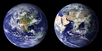
The Blue Marble, a photograph of the planet Earth made on 7 December 1972 by the crew of the Apollo 17 spacecraft.
The world is the totality of entities, the whole of reality, or everything that exists. The nature of the world has been conceptualized differently in different fields. Some conceptions see the world as unique while others talk of a "plurality of worlds". Some treat the world as one simple object while others analyze the world as a complex made up of parts.
In scientific cosmology, the world or universe is commonly defined as "[t]he totality of all space and time; all that is, has been, and will be". Theories of modality talk of possible worlds as complete and consistent ways how things could have been. Phenomenology, starting from the horizon of co-given objects present in the periphery of every experience, defines the world as the biggest horizon or the "horizon of all horizons". In philosophy of mind, the world is contrasted with the mind as that which is represented by the mind. Theology conceptualizes the world in relation to God, for example, as God's creation, as identical to God or as the two being interdependent. In religions, there is a tendency to downgrade the material or sensory world in favor of a spiritual world to be sought through religious practice. A comprehensive representation of the world and our place in it, as is found in religions, is known as a worldview. Cosmogony is the field that studies the origin or creation of the world while eschatology refers to the science or doctrine of the last things or of the end of the world.
Poster advertising the Brussels International Exposition in 1897 A world's fair, also known as a universal exhibition or an expo, is a large global exhibition designed to showcase the achievements of nations. These exhibitions vary in character and are held in different parts of the world at a specific site for a period of time, typically between three and six months.
The term "world's fair" is commonly used in the United States, while the French term, Exposition universelle ("universal exhibition") is used in most of Europe and Asia; other terms include World Expo or Specialised Expo, with the word expo used for various types of exhibitions since at least 1958. (Full article...)
Image 2
Water covers about 71% of Earth's surface.
The origin of water on Earth is the subject of a body of research in the fields of planetary science, astronomy, and astrobiology. Earth is unique among the rocky planets in the Solar System in having oceans of liquid water on its surface. Liquid water, which is necessary for all known forms of life, continues to exist on the surface of Earth because the planet is at a far enough distance (known as the habitable zone) from the Sun that it does not lose its water, but not so far that low temperatures cause all water on the planet to freeze.
It was long thought that Earth's water did not originate from the planet's region of the protoplanetary disk. Instead, it was hypothesized water and other volatiles must have been delivered to Earth from the outer Solar System later in its history. Recent research, however, indicates that hydrogen inside the Earth played a role in the formation of the ocean. The two ideas are not mutually exclusive, as there is also evidence that water was delivered to Earth by impacts from icy planetesimals similar in composition to asteroids in the outer edges of the asteroid belt. (Full article...)
The report "assesses the ability of countries to provide high levels of prosperity to their citizens". This in turn depends on how productively a country uses available resources. Therefore, the Global Competitiveness Index measures the set of institutions, policies, and factors that set the sustainable current and medium-term levels of economic prosperity." (Full article...)
Image 4
The Blue Marble, taken by either Ron Evans or Harrison Schmitt of the Apollo 17 crew in 1972. The original photograph was taken with the South Pole facing the top, however this version is the most widely distributed.
The Blue Marble is a photograph of Earth taken on December 7, 1972, from a distance of around 29,400 kilometers (18,300 miles) from the planet's surface.
The original image (NASA designation AS17-148-22727) was taken by either Ron Evans or Harrison Schmitt of the crew of the Apollo 17 spacecraft on its way to the Moon, and showed the Earth with the south pole facing upwards; since then, a cropped and rotated version has become one of the most reproduced images in history. (Full article...)
The era of the Scientific Renaissance focused to some degree on recovering the knowledge of the ancients and is considered to have culminated in Isaac Newton's 1687 publication Principia which formulated the laws of motion and universal gravitation, thereby completing the synthesis of a new cosmology. The subsequent Age of Enlightenment saw the concept of a scientific revolution emerge in the 18th-century work of Jean Sylvain Bailly, who described a two-stage process of sweeping away the old and establishing the new. There continues to be scholarly engagement regarding the boundaries of the Scientific Revolution and its chronology. (Full article...)
Image 6
Medical professionals treating a COVID-19 patient in critical condition in an intensive care unit in São Paulo in May 2020
Conjectured illustration of the scorched Earth after the Sun has entered the red giant phase, about 5–7 billion years from now
The biological and geological future of Earth can be extrapolated based on the estimated effects of several long-term influences. These include the chemistry at Earth's surface, the cooling rate of the planet's interior, the gravitational interactions with other objects in the Solar System, and a steady increase in the Sun's luminosity. An uncertain factor is the pervasive influence of technology introduced by humans, such as climate engineering, which could cause significant changes to the planet. For example, the current Holocene extinction is being caused by technology, and the effects may last for up to five million years. In turn, technology may result in the extinction of humanity, leaving the planet to gradually return to a slower evolutionary pace resulting solely from long-term natural processes.
Image 6Conjectured illustration of the scorched Earth after the Sun has entered the red giant phase, about 5–7 billion years from now (from Earth)
Image 7Earth's night-side upper atmosphere appearing from the bottom as bands of afterglow illuminating the troposphere in orange with silhouettes of clouds, and the stratosphere in white and blue. Next the mesosphere (pink area) extends to the orange and faintly green line of the lowest airglow, at about one hundred kilometers at the edge of space and the lower edge of the thermosphere (invisible). Continuing with green and red bands of aurorae stretching over several hundred kilometers. (from Earth)
Image 11Artist's conception of Hadean Eon Earth, when it was much hotter and inhospitable to all forms of life. (from History of Earth)
Image 12An animation of the changing density of productive vegetation on land (low in brown; heavy in dark green) and phytoplankton at the ocean surface (low in purple; high in yellow) (from Earth)
Image 15The replicator in virtually all known life is deoxyribonucleic acid. DNA is far more complex than the original replicator and its replication systems are highly elaborate. (from History of Earth)
Image 17Tiktaalik, a fish with limb-like fins and a predecessor of tetrapods. Reconstruction from fossils about 375 million years old. (from History of Earth)
Image 18An artist's impression of the Archean, the eon after Earth's formation, featuring round stromatolites, which are early oxygen-producing forms of life from billions of years ago. After the Late Heavy Bombardment, Earth's crust had cooled, its water-rich barren surface is marked by continents and volcanoes, with the Moon still orbiting Earth half as far as it is today, appearing 2.8 times larger and producing strong tides. (from Earth)
Image 27Exaggerated illustration of Earth's elliptical orbit around the Sun, marking that the orbital extreme points (apoapsis and periapsis) are not the same as the four seasonal extreme points, the equinox and solstice (from Earth)
Image 43Geologic map of North America, color-coded by age. From most recent to oldest, age is indicated by yellow, green, blue, and red. The reds and pinks indicate rock from the Archean.
Image 44Japanese depiction of a Portuguese carrack. European maritime innovations led to proto-globalization.
Image 45A map of heat flow from Earth's interior to the surface of Earth's crust, mostly along the oceanic ridges (from Earth)
Image 50Cave paintings, Lascaux, France, c. 17,000 BCE
Image 51Earth's western hemisphere showing topography relative to Earth's center instead of to mean sea level, as in common topographic maps (from Earth)
Image 52Change in average surface air temperature and drivers for that change. Human activity has caused increased temperatures, with natural forces adding some variability. (from Earth)
Image 53Artist's impression of the enormous collision that probably formed the Moon (from History of Earth)
Image 55A reconstruction of Pannotia (550 Ma). (from History of Earth)
Image 56Artist's impression of Earth during the later Archean, the largely cooled planetary crust and water-rich barren surface, marked by volcanoes and continents, features already roundmicrobialites. The Moon, still orbiting Earth much closer than today and still dominating Earth's sky, produced strong tides. (from History of Earth)
Image 57Earth's axial tilt causing different angles of seasonal illumination at different orbital positions around the Sun (from Earth)
Image 58Pangaea was a supercontinent that existed from about 300 to 180 Ma. The outlines of the modern continents and other landmasses are indicated on this map. (from History of Earth)
Image 59Shanghai. China urbanized rapidly in the 21st century.
Image 66A reconstruction of human history based on fossil data. (from History of Earth)
Image 67Trilobites first appeared during the Cambrian period and were among the most widespread and diverse groups of Paleozoic organisms. (from History of Earth)
Image 78A view of Earth with its global ocean and cloud cover, which dominate Earth's surface and hydrosphere; at Earth's polar regions, its hydrosphere forms larger areas of ice cover. (from Earth)
Image 79A schematic view of Earth's magnetosphere with solar wind flowing from left to right (from Earth)
Image 87Map of peopling of the world (Southern Dispersal paradigm), in thousands of years ago.
Image 88A 2012 artistic impression of the early Solar System's protoplanetary disk from which Earth and other Solar System bodies were formed (from Earth)
Image 91Artist's impression of a Hadean landscape with the relatively newly formed Moon still looming closely over Earth and both bodies sustaining strong volcanism. (from History of Earth)
... that Eva Duldig, who was interned by Australia during the Second World War, later represented the country at the Wimbledon Championships?
... that The Constellation of Leo, a group portrait of people from Italy's art world, was exhibited with a note that read "not without a trace of irony"?
Mali, officially the Republic of Mali, is a landlocked country in West Africa. Mali is the eighth-largest country in Africa, with an area of over 1,241,238 square kilometres (479,245 sq mi). The country is bordered to the north by Algeria, to the east by Niger, to the northwest by Mauritania, to the south by Burkina Faso and Ivory Coast, and to the west by Guinea and Senegal. The population of Mali is 21.9 million,0 67% of which was estimated to be under the age of 25 in 2017. Its capital and largest city is Bamako. The country has 13 official languages, of which Bambara is the most commonly spoken.
The sovereign state of Mali consists of 19 regions; its borders on the north reach deep into the middle of the Sahara Desert. The country's southern part, where the majority of inhabitants live, is in the Sudanian savanna and both the Niger and Senegal rivers pass through. The country's economy centres on agriculture and mining. Its most prominent natural resources include gold, of which it is the third largest producer in Africa, as well as salt. (Full article...)
Protected areas in Tanzania (Hifahdi za Mali hai za Tanzania, in Swahili) are extremely varied, ranging from sea habitats over grasslands to the top of the Kilimanjaro, the tallest mountain in Africa. About a third of the country's total area is protected to a certain degree as a national park, game reserve, marine park, forest reserve or the like. 840 protected areas are spread across 7,330 km2 of ocean and 361,594 km2 of land in Tanzania. The coastal and marine areas are less protected than terrestrial ecosystems, which are given the highest level of protection. Tanzania is one of the world's major biodiversity hotspots thanks to its vast national parks, "the Eastern Arc" mountains, wetlands, coastal forests, marine, and freshwater systems as remarkable reservoirs of plant and animal species. A wide range of endemic species of birds, reptiles, snakes, amphibians, wild coffee variations, and the well-known African violet flower can also be found in Tanzania. (Full article...)
Based on the Collaborative Australian Protected Area Database (CAPAD) 2020 data there are 2136 separate terrestrial protected areas with a total land area of 7,696,641 hectares (19,018,810 acres) (9.61% of the state's area). CAPAD data also shows 18 marine protected areas with a total area of 348,849 hectares (862,020 acres), covering 39.63% of NSW waters. (Full article...)
Image 5
Forests in the state of Himachal Pradesh (northern India) currently cover an area of nearly 37,939 square kilometres (14,648 sq mi), which is about 68.16% of the total land area of the state. The forests were once considered to be the main source of income of the state and most of the original forests were clear felled. The emphasis has shifted, however, from exploitation to conservation. The state government aims to increase forest cover to 50% of the total land area. There have been various projects, including the establishment of protected areas such as National Parks, designed to preserve and expand the forests. (Full article...)
In the Philippines, Protected Areas are administered by the Department of Environment and Natural Resources (DENR)'s Biodiversity Management Bureau under the National Integrated Protected Areas System (NIPAS) Act of 1992. As of 2020, there are 244 Protected Areas in the Philippines covering a total area of about 7,760,000 hectares (19,200,000 acres) – 15.4% of the Philippines' total area. (Full article...)
Within each classification of reserve there may be a variation of IUCN categories Australia is a signatory to the Convention of Biological Diversity and as such has obligations to report the status of its National Reserve System.IUCN provides on its website a prescription for activities consistent with the categorisation system. Changes made to the Nature Conservation Act 2002 in 2014 permit timber harvesting. These changes made in addition to the already established right to access minerals means that many of the IUCN categorisations assigned to individual reserves in Tasmania are no longer fit for purpose. In addition many reserves have had their reserve status downgraded from a class excluding timber harvesting and mineral extraction to ones where these activities are now permitted. This mis-application of the IUCN protected area categories needs to be remedied or the reserves protected land class under the Nature Conservation Act 2002 should be adjusted to reflect its currently assigned IUCN category. (Full article...)
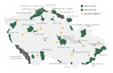
Map of protected areas of the Czech Republic: national parks (grey) and protected landscape areas (green) There are several types of protected areas of the Czech Republic. The main form of landscape protection is delimitation of special protected areas. All the types of protected areas are determined by law. (Full article...)
Redwood grove in Redwood National Park According to the California Protected Areas Database (CPAD), in the state of California, United States, there are over 14,000 inventoried protected areas administered by public agencies and non-profits. In addition, there are private conservation areas and other easements. They include almost one-third of California's scenic coastline, including coastal wetlands, estuaries, beaches, and dune systems. The California State Parks system alone has 270 units and covers 1.3 million acres (5,300 km2), with over 280 miles (450 km) of coastline, 625 miles (1,006 km) of lake and river frontage, nearly 18,000 campsites, and 3,000 miles (5,000 km) of hiking, biking, and equestrian trails.
Obtaining an accurate total of all protected land in California and elsewhere is a complex task. Many parcels have inholdings, private lands within the protected areas, which may or may not be accounted for when calculating total area. Also, occasionally one parcel of land is included in two or more inventories. Over 90% of Yosemite National Park for example, is listed both as wilderness by the National Wilderness Preservation System, and as national park land by the National Park Service. The Cosumnes River Preserve is an extreme example, owned and managed by a handful of public agencies and private landowners, including the Bureau of Land Management, the County of Sacramento and The Nature Conservancy. Despite the difficulties, the CPAD gives the total area of protected land at 49,294,000 acres (199,490 km2), or 47.05% of the state (not including easements); a considerable amount for the most populous state in the country. (Full article...)
Image 6Only a few of the largest large igneous provinces appear (coloured dark purple) on this geological map, which depicts crustal geologic provinces as seen in seismic refraction data


 Cross-section through a liposome (from History of Earth)
 A 580 million year old fossil of Spriggina floundensi, an animal from the Ediacaran period. Such life forms could have been ancestors to the many new forms that originated in the Cambrian Explosion. (from History of Earth)
 Great Mosque of Kairouan, Tunisia, founded 670 CE
 A computer-generated image mapping the prevalence of artificial satellites and space debris around Earth in geosynchronous and low Earth orbit (from Earth)

 Earth's night-side upper atmosphere appearing from the bottom as bands of afterglow illuminating the troposphere in orange with silhouettes of clouds, and the stratosphere in white and blue. Next the mesosphere (pink area) extends to the orange and faintly green line of the lowest airglow, at about one hundred kilometers at the edge of space and the lower edge of the thermosphere (invisible). Continuing with green and red bands of aurorae stretching over several hundred kilometers. (from Earth)
 Tracy Caldwell Dyson, a NASA astronaut, observing Earth from the Cupola module at the International Space Station on 11 September 2010 (from Earth)
 View of Earth from the Moon by the Lunar Reconnaissance Orbiter (from Earth)
 Obelisk of Axum, Ethiopia
 Artist's conception of Hadean Eon Earth, when it was much hotter and inhospitable to all forms of life. (from History of Earth)
 An animation of the changing density of productive vegetation on land (low in brown; heavy in dark green) and phytoplankton at the ocean surface (low in purple; high in yellow) (from Earth)
 Fall of the Berlin Wall, 1989
 The replicator in virtually all known life is deoxyribonucleic acid. DNA is far more complex than the original replicator and its replication systems are highly elaborate. (from History of Earth)
 Tiktaalik, a fish with limb-like fins and a predecessor of tetrapods. Reconstruction from fossils about 375 million years old. (from History of Earth)
 An artist's impression of the Archean, the eon after Earth's formation, featuring round stromatolites, which are early oxygen-producing forms of life from billions of years ago. After the Late Heavy Bombardment, Earth's crust had cooled, its water-rich barren surface is marked by continents and volcanoes, with the Moon still orbiting Earth half as far as it is today, appearing 2.8 times larger and producing strong tides. (from Earth)

 An artist's rendering of a protoplanetary disk (from History of Earth)
 The pale orange dot, an artist's impression of the early Earth which might have appeared orange through its hazy methane rich prebiotic second atmosphere. Earth's atmosphere at this stage was somewhat comparable to today's atmosphere of Titan. (from History of Earth)
 Last Moon landing: Apollo 17 (1972)
 A banded iron formation from the 3.15 Ga Moodies Group, Barberton Greenstone Belt, South Africa. Red layers represent the times when oxygen was available; gray layers were formed in anoxic circumstances. (from History of Earth)

 A composite image of artificial light emissions at night on a map of Earth (from Earth)
 Artist's conception of Devonian flora (from History of Earth)
 Image of the physical world, captured by the Hubble Space Telescope (from World)
 A view of Earth with different layers of its atmosphere visible: the troposphere with its clouds casting shadows, a band of stratospheric blue sky at the horizon, and a line of green airglow of the lower thermosphere around an altitude of 100 km, at the edge of space (from Earth)
 Angkor Wat temple complex, Cambodia, early 12th century
 Taj Mahal, Mughal Empire, India
 Chennakesava Temple, Belur, India
 Yggdrasil, an attempt to reconstruct the Norse world tree which connects the heavens, the world, and the underworld. (from World)
 Satellite time lapse imagery of Earth's rotation showing axis tilt (from Earth)
 Artist's rendition of an oxinated fully-frozen Snowball Earth with no remaining liquid surface water. (from History of Earth)
 Vitruvian Man by Leonardo da Vinci epitomizes the advances in art and science seen during the Renaissance. (from History of Earth)
 Geologic map of North America, color-coded by age. From most recent to oldest, age is indicated by yellow, green, blue, and red. The reds and pinks indicate rock from the Archean.
 Japanese depiction of a Portuguese carrack. European maritime innovations led to proto-globalization.
 A map of heat flow from Earth's interior to the surface of Earth's crust, mostly along the oceanic ridges (from Earth)
 Battle during 1281 Mongol invasion of Japan
 A pillar at Göbekli Tepe
 Lithified stromatolites on the shores of Lake Thetis, Western Australia. Archean stromatolites are the first direct fossil traces of life on Earth. (from History of Earth)
 Earth's western hemisphere showing topography relative to Earth's center instead of to mean sea level, as in common topographic maps (from Earth)
 Change in average surface air temperature and drivers for that change. Human activity has caused increased temperatures, with natural forces adding some variability. (from Earth)
 Artist's impression of the enormous collision that probably formed the Moon (from History of Earth)
 A reconstruction of Pannotia (550 Ma). (from History of Earth)
 Earth's axial tilt causing different angles of seasonal illumination at different orbital positions around the Sun (from Earth)
 Pangaea was a supercontinent that existed from about 300 to 180 Ma. The outlines of the modern continents and other landmasses are indicated on this map. (from History of Earth)
 Shanghai. China urbanized rapidly in the 21st century.
 A composite image of Earth, with its different types of surface discernible: Earth's surface dominating Ocean (blue), Africa with lush (green) to dry (brown) land and Earth's polar ice in the form of Antarctic sea ice (grey) covering the Antarctic or Southern Ocean and the Antarctic ice sheet (white) covering Antarctica. (from Earth)
 Olmec colossal head, now at the Museo de Antropología de Xalapa
 A Benin Bronze head from Nigeria

 Ajloun Castle, Jordan
 A reconstruction of human history based on fossil data. (from History of Earth)
 Trilobites first appeared during the Cambrian period and were among the most widespread and diverse groups of Paleozoic organisms. (from History of Earth)
 Persepolis, Achaemenid Empire, 6th century BCE
 Empires of the world in 1898
 Chloroplasts in the cells of a moss (from History of Earth)
 Machu Picchu, Inca Empire, Peru
 First airplane, the Wright Flyer, flew on 17 December 1903.
 The Pantheon, originally a Roman temple, now a Catholic church
 Earth's history with time-spans of the eons to scale (from History of Earth)
 Graph showing range of estimated partial pressure of atmospheric oxygen through geologic time (from History of Earth)
 "Lucy", the first Australopithecus afarensis skeleton found. Lucy was only 1.06 m (3 ft 6 in) tall.
 A view of Earth with its global ocean and cloud cover, which dominate Earth's surface and hydrosphere; at Earth's polar regions, its hydrosphere forms larger areas of ice cover. (from Earth)
 A schematic view of Earth's magnetosphere with solar wind flowing from left to right (from Earth)
 Dinosaurs were the dominant terrestrial vertebrates throughout most of the Mesozoic (from History of Earth)
 An artist's impression of ice age Earth at glacial maximum. (from History of Earth)
 Earth's land use for human agriculture in 2019 (from Earth)
 Florence, birthplace of the Italian Renaissance
 Standing Buddha from Gandhara, 2nd century CE
 Great Pyramids of Giza, Egypt
 Map of peopling of the world (Southern Dispersal paradigm), in thousands of years ago.
 A 2012 artistic impression of the early Solar System's protoplanetary disk from which Earth and other Solar System bodies were formed (from Earth)
 Ming dynasty section, Great Wall of China
 Artist's impression of a Hadean landscape with the relatively newly formed Moon still looming closely over Earth and both bodies sustaining strong volcanism. (from History of Earth)
 Notre-Dame de Paris, France


.svg)


.jpg)


.jpg)


.jpg)


.jpeg)


.svg)
 The world map by Gerardus Mercator (1569), the first map in the well-known Mercator projection
 The Goode homolosine projection is a pseudocylindrical, equal-area, composite map projection used for world maps.
 A plate tectonics map with volcano locations indicated with red circles
 1516 map of the world by Martin Waldseemüller
 United Nations Human Development Index map by country (2016)
 Only a few of the largest large igneous provinces appear (coloured dark purple) on this geological map, which depicts crustal geologic provinces as seen in seismic refraction data
 Index map from the International Map of the World (1:1,000,000 scale)
 Mollweide projection of the world
 Time zones of the world


 Commons
 Wikibooks
 Wikidata
 Wikinews
 Wikiquote
 Wikisource
 Wikispecies
 Wikiversity
 Wikivoyage
 Wiktionary


