
Portal:Myanmar
ကြိုဆိုပါတယ်။ / Welcome to the Myanmar Portal 

Myanmar, officially the Republic of the Union of Myanmar and also known as Burma (the official name until 1989), is a country in Southeast Asia. It is the largest country by area in Mainland Southeast Asia and has a population of about 55 million. It is bordered by Bangladesh and India to its northwest, China to its northeast, Laos and Thailand to its east and southeast, and the Andaman Sea and the Bay of Bengal to its south and southwest. The country's capital city is Naypyidaw, and its largest city is Yangon (formerly Rangoon).
Myanmar is a member of the East Asia Summit, Non-Aligned Movement, ASEAN, and BIMSTEC, but it is not a member of the Commonwealth of Nations despite once being part of the British Empire. Myanmar is a Dialogue Partner of the Shanghai Cooperation Organization. The country is very rich in natural resources, such as jade, gems, oil, natural gas, teak and other minerals, as well as also endowed with renewable energy, having the highest solar power potential compared to other countries of the Great Mekong Subregion. However, Myanmar has long suffered from instability, factional violence, corruption, poor infrastructure, as well as a long history of colonial exploitation with little regard to human development. In 2013, its GDP (nominal) stood at US$56.7 billion and its GDP (PPP) at US$221.5 billion. The income gap in Myanmar is among the widest in the world, as a large proportion of the economy is controlled by cronies of the military junta. Myanmar is one of the least developed countries; as of 2020, according to the Human Development Index, it ranks 147 out of 189 countries in terms of human development, the lowest in Southeast Asia. Since 2021, more than 600,000 people were displaced across Myanmar due to the surge in violence post-coup, with more than 3 million people in dire need of humanitarian assistance. (Full article...)
Selected articles -
-

The Saffron Revolution (Burmese: ရွှေဝါရောင်တော်လှန်ရေး) was a series of economic and political protests and demonstrations that took place during August, September, and October 2007 in Myanmar. The protests were triggered by the decision of the national military government to remove subsidies on the sales prices of fuel. The national government is the only supplier of fuels and the removal of the price subsidy immediately caused diesel and petrol prices to increase by 66–100% and the price of compressed natural gas for buses to increase 500% in less than a week.
The various protests were led by students, political activists, including women, and Buddhist monks and took the form of a campaign of nonviolent resistance, sometimes also called civil resistance. (Full article...) -
The Burma Railway, also known as the Siam–Burma Railway, Thai–Burma Railway and similar names, or as the Death Railway, is a 415 km (258 mi) railway between Ban Pong, Thailand, and Thanbyuzayat, Burma (now called Myanmar). It was built from 1940 to 1943 by South East Asian civilians abducted and forced to work by the Japanese and a smaller group of captured Allied soldiers, to supply troops and weapons in the Burma campaign of World War II. It completed the rail link between Bangkok, Thailand, and Rangoon, Burma. The name used by the Japanese Government was Tai–Men Rensetsu Tetsudō (泰緬連接鉄道), which means Thailand-Burma-Link-Railway.
At least 250,000 Southeast Asian civilians were subjected to forced labour to ensure the construction of the Death Railway and more than 90,000 civilians died building it, as did around 12,000 Allied soldiers. The workers on the Thai side of the railway were Tamils, Malays, and fewer Chinese civilians from Malaya. Possibly over 345,000 died while working, with the death rate per month rivaling that of Auschwitz. (Full article...) -

The Burmese–Siamese War also known as the War of the second fall (Thai: สงครามคราวเสียกรุงครั้งที่สอง, Burmese: ယိုးဒယား-မြန်မာစစ် (၁၇၆၅–၁၇၆၇)) was the second military conflict between Burma under Konbaung dynasty and Ayutthaya Kingdom under Siamese Ban Phlu Luang dynasty that lasted from 1765 until 1767, and the war that ended the 417-year-old Ayutthaya Kingdom. Nonetheless, the Burmese were soon forced to give up their hard-won gains when the Chinese invasions of their homeland forced a complete withdrawal by the end of 1767. A new Siamese dynasty, to which the current Thai monarchy traces its origins, emerged to reunify Siam by 1771.
This war was the continuation of the 1759–60 war. The casus belli of this war was also the control of the Tenasserim coast and its trade, and Siamese support for rebels in the Burmese border regions. The war began in August 1765 when a 20,000-strong northern Burmese army invaded northern Siam, and was joined by three southern armies of over 20,000 in October, in a pincer movement on Ayutthaya. By late-January 1766, the Burmese armies had overcome numerically superior but poorly coordinated Siamese defenses, and converged before the Siamese capital. (Full article...) -
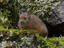
Forrest's pika (Ochotona forresti) is a species of mammal in the pika family, Ochotonidae. It is found in Bhutan, China, India, and Myanmar. The summer dorsal pelage and ventral pelage are dark rufous or blackish brown, and the winter dorsal pelage is a grayish brown, slightly lighter in tone than the ventral pelage. It is a generalist herbivore. It was assessed by the IUCN Red List of Endangered Species as insufficiently known in 1994, as near threatened in 1996, and re-assessed in 2008 as a species of least concern. (Full article...) -
The 2010–2012 Myanmar border clashes were a series of skirmishes between the Tatmadaw (Myanmar Armed Forces) on one side, and the DKBA-5 and the Karen National Liberation Army (KNLA) on the other. The clashes erupted along the border with Thailand shortly after Myanmar's general election on 7 November 2010. An estimated 10,000 refugees have fled into nearby neighbouring Thailand to escape the violent conflict. There was concern that due to discontent with the elections, and speculations of electoral fraud, that the conflict could escalate into a civil war. (Full article...)
-
Yangon International Airport (Burmese: ရန်ကုန်အပြည်ပြည်ဆိုင်ရာလေဆိပ်; MLCTS: rankun apranyprany hcuingra lehcip [jàɴɡòʊɰ̃ əpjìpjì sʰàɪɴjà lèzeɪʔ]) (IATA: RGN, ICAO: VYYY) is the primary and busiest international airport of Myanmar. The airport is located in Mingaladon, 15 kilometres (9.3 mi) north of central Yangon. All ten Myanmar carriers and about 30 international airlines operate at Yangon International Airport. The airport is also colloquially known as Mingaladon Airport due to its location. (Full article...) -
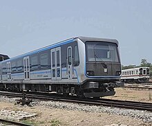
Yangon Circular Railway (Burmese: ရန်ကုန် မြို့ပတ် ရထား [jàɰ̃ɡòʊɰ̃ mjo̰baʔ jətʰá]) is the local commuter rail network that serves the Yangon metropolitan area. Operated by Myanma Railways, the 45.9-kilometre (28.5 mi) 39-station loop system connects satellite towns and suburban areas to the city. Circa 2008–2010, the railway had about 200 coaches, had 20 daily runs, and sold 100,000 to 150,000 tickets daily.
The railway is heavily utilized by lower-income commuters, as it is (along with buses) the cheapest method of transportation in Yangon.
The hours of service have been consistent over the years, from 3:45 am to 10:15 pm daily. In 2011, the cost of a ticket for a distance of 15 miles was two hundred kyats (~eighteen US cents), and that for over 15 miles was four hundred kyats (~37 US cents). In the new currency (introduced in 2012) long distance tickets are 200 kyat (~20 US cents). (Full article...) -

Effect of the 2004 Indian Ocean earthquake on Myanmar
Official reports from the government of Myanmar (Burma) cite a death toll of 90 due to the tsunami caused by the 2004 Indian Ocean earthquake on 26 December 2004. However, some estimates put the toll at between 400 and 600. 30,000 citizens of Burma were estimated to be in need of shelter, food and water, and 788 buildings were reported damaged and destroyed.
An NGO estimated that 2,500 citizens of Burma based in Phang Nga Province, Thailand during the event may have been killed, and that 7,000 Burmese were still unaccounted for. Many of these missing were, however, not presumed to be dead. Many refugees fled to Thailand's interior after the destruction, or were deported or chased back into the hills that divide the countries by Thai authorities. (Full article...) -

Black and white photograph of logging in Myanmar taken by a Bombay Burmah Trading Corporation official during British rule.
According to a report by the Food and Agriculture Organization of the United Nations, Myanmar (also known as Burma) lost 19%, or 7,445,000 hectares (28,750 sq mi), of forest between 1990 and 2010. With forest covering as much as 70% of Burma at the time of independence, there were only slightly more than 48% forest cover left as of 2014. The deforestation rate of Myanmar has declined from 0.95% per year in the years 1990–2010 to about 0.3% per year and deforestation in Myanmar is now less than other countries of the region such as Indonesia or Vietnam, but still remains an important environmental issue. Three main factors contribute to continued deforestation: unsustainable and illegal logging, unresolved land rights and land disputes and extensive agricultural development.
Myanmar possesses the largest expanse of tropical forest in mainland Southeast Asia with a biodiversity much greater than temperate forests. As of 2010, Burma's living forest biomass holds 1,654 million metric tons of carbon and is home to over 80 endemic species. Despite the diversity and size of Burma's forests, only 6.3% of the land is protected and much of it is under the threat of deforestation. (Full article...) -

Myitkyina (Burmese: မြစ်ကြီးနားမြို့; MLCTS: mrac kri: na: mrui., pronounced [mjɪʔtɕíná]; (Eng; mitchinar) Jinghpaw: Myitkyina, [mjìtkjí̠ná]) is the capital city of Kachin State in Myanmar (Burma), located 1,480 kilometers (920 mi) from Yangon, and 785 kilometers (488 mi) from Mandalay. In Burmese it means "near the big river", and Myitkyina is on the west bank of the Ayeyarwady River, just below 40 kilometers (25 mi) from Myit-son (Burmese for confluence) of its two headstreams (the Mali and N'mai rivers). It is the northernmost river port and railway terminus in Myanmar. The city is served by Myitkyina Airport. (Full article...)


_map_-_EN_-_001.jpg)


_-_panoramio_(1).jpg)
Did you know (auto-generated) -

- ... that while defending Zaw Myint Maung following his arrest by the Myanmar junta, lawyer Ywet Nu Aung was herself arrested and charged?
- ... that squatters in Myanmar were punished for protesting against the 2021 coup d'état by being evicted?
- ... that the Burmese Buddhist monk Sagyo Thu-Myat successfully lobbied for the recalibration of the Burmese calendar?
- ... that Maung O, Prince of Salin, and his sister Nanmadaw Me Nu became de facto rulers of Burma when King Bagyidaw was suffering from depression?
- ... that one academic described the introduction of femboys to Myanmar as a tactic to achieve an "ideological revolution"?
- ... that the Burmese and South Korean first ladies held their first informal conversation 44 years after the establishment of bilateral relations between the two countries?
- ... that Thinzar Shunlei Yi hid in the Burmese jungle for a month and joined a rebel militia following the 2021 Myanmar coup d'état?
- ... that Aung Myo Min, Union Minister of Human Rights for the National Unity Government of Myanmar, is the country's first openly LGBT minister?
Related portals and projects
General images -
-
 Vegetable stall on the roadside at the Madras Lancer Lines, Mandalay, January 1886. Photographer: Hooper, Willoughby Wallace (1837–1912). (from History of Myanmar)
 -
 The restored Taungoo or Nyaungyan dynasty c. 1650 CE. (from History of Myanmar)
 -
 British soldiers on patrol in the ruins of the Burmese town of Bahe during the advance on Mandalay, January 1945. (from History of Myanmar)
 -
 Protesters in Yangon carrying signs reading "Free Daw Aung San Suu Kyi" on 8 February 2021. (from History of Myanmar)
 -
 19th-century funeral cart and spire, which would form part of the procession from the home to the place of cremation (from Culture of Myanmar)
 -
 Two female musicians play the saung at a performance in Mandalay. (from Culture of Myanmar)
 -
 Mount Popa, a dormant volcano in the Central Lowlands (from Geography of Myanmar)
 -
 Temples at Mrauk U, was the capital of the Mrauk U Kingdom, which ruled over what is now Rakhine State. (from History of Myanmar)
 -

-
 Former US President Barack Obama poses barefoot on the grounds of Shwedagon Pagoda, one of Myanmar's major Buddhist pilgrimage sites. (from Culture of Myanmar)
 -
 Boxing match, 19th-century watercolour (from Culture of Myanmar)
 -
 The paddle steamer Ramapoora (right) of the British India Steam Navigation Company on the Rangoon river having just arrived from Moulmein. 1895. Photographers: Watts and Skeen (from History of Myanmar)
 -
 Grandfather Island, Dawei (from Geography of Myanmar)
 -
 Protesters in Yangon with a banner that reads non-violence: national movement in Burmese, in the background is Shwedagon Pagoda. (from History of Myanmar)
 -
 Political Map of Burma (Myanmar) c. 1450 CE. (from History of Myanmar)
 -
 Salween river at Mae Sam Laep on the Thai-Myanmar border (from Geography of Myanmar)
 -

-
 A bull fight, 19th-century watercolour (from Culture of Myanmar)
 -
 A wide range of Burmese lacquerware from Bagan (from Culture of Myanmar)
 -
 Aung San Suu Kyi addresses crowds at the NLD headquarters shortly after her release. (from History of Myanmar)
 -

-
 British soldiers dismantling cannons belonging to King Thibaw's forces, Third Anglo-Burmese War, Ava, 27 November 1885. Photographer: Hooper, Willoughby Wallace (1837–1912). (from History of Myanmar)
 -
 A wedding procession, with the groom and bride dressed in traditional Burmese wedding clothes, reminiscent of royal attire (from Culture of Myanmar)
 -
 Jade Mine in Hpakant (from Geography of Myanmar)
 -
 The shores of Irrawaddy River at Nyaung-U, Bagan (from Geography of Myanmar)
 -
 British soldiers remove their shoes at the entrance of Shwedagon Pagoda. To the left, a sign reads "Foot wearing is strictly prohibited" in Burmese, English, Tamil, and Urdu. (from Culture of Myanmar)
 -
 Mountains near Pindaya on the Shan Plateau (from Geography of Myanmar)
 -
 Saint Mary's Cathedral in Downtown Yangon is the largest Roman Catholic cathedral in Burma. (from Culture of Myanmar)
 -
 Pagan Kingdom during Narapatisithu's reign. Burmese chronicles also claim Kengtung and Chiang Mai. Core areas shown in darker yellow. Peripheral areas in light yellow. Pagan incorporated key ports of Lower Burma into its core administration by the 13th century. (from History of Myanmar)
 -

-
 Sculpture of Myanmar mythical lion (from Culture of Myanmar)
 -
 A group of Buddhist worshipers at Shwedagon Pagoda, an important religious site for Burmese Buddhists (from Culture of Myanmar)
 -
 Recorder's Court on Sule Pagoda Road, with the Sule Pagoda at the far end, Rangoon, 1868. Photographer: J. Jackson. (from History of Myanmar)
 -
 Myanmar (Burma) map of Köppen climate classification (from Geography of Myanmar)
 -
 A theatrical performance of the Mon dance (from Culture of Myanmar)
 -
 A large fracture on the Mingun Pahtodawgyi caused by the 1839 Ava earthquake. (from Geography of Myanmar)
 -
 Portuguese ruler and soldiers mounting an Elephant. Philips, Jan Caspar (draughtsman and engraver) (from History of Myanmar)
 -
 Hlei pyaingbwè - a Burmese regatta (from Culture of Myanmar)
 -
 Aerial view of a burned Rohingya village in Rakhine state, Myanmar, September 2017 (from History of Myanmar)
 -
 Myinhkin thabin - equestrian sport (from Culture of Myanmar)


_headquarter.jpg)


Major topics
Categories

More topics

Associated Wikimedia
The following Wikimedia Foundation sister projects provide more on this subject:
-
 Commons
Free media repository -
 Wikibooks
Free textbooks and manuals -
 Wikidata
Free knowledge base -
 Wikinews
Free-content news -
 Wikiquote
Collection of quotations -
 Wikisource
Free-content library -
 Wikiversity
Free learning tools -
 Wikivoyage
Free travel guide -
 Wiktionary
Dictionary and thesaurus


